

Early days
“Eric Tiltman set up the original business known as EVE Tiltman. He was an engineering surveyor and my father, Mike Powers had worked with Eric on a few projects in the late 60s early 70s . Eric began to take on some larger projects and approached Mike to partner up with him. Mike and Eric set up an equal partnership in 1973, called EVE Tiltman and Partner. At that time, the work focused on large scale open cast mining, carrying out survey control establishment, setting out and earthwork calculations.
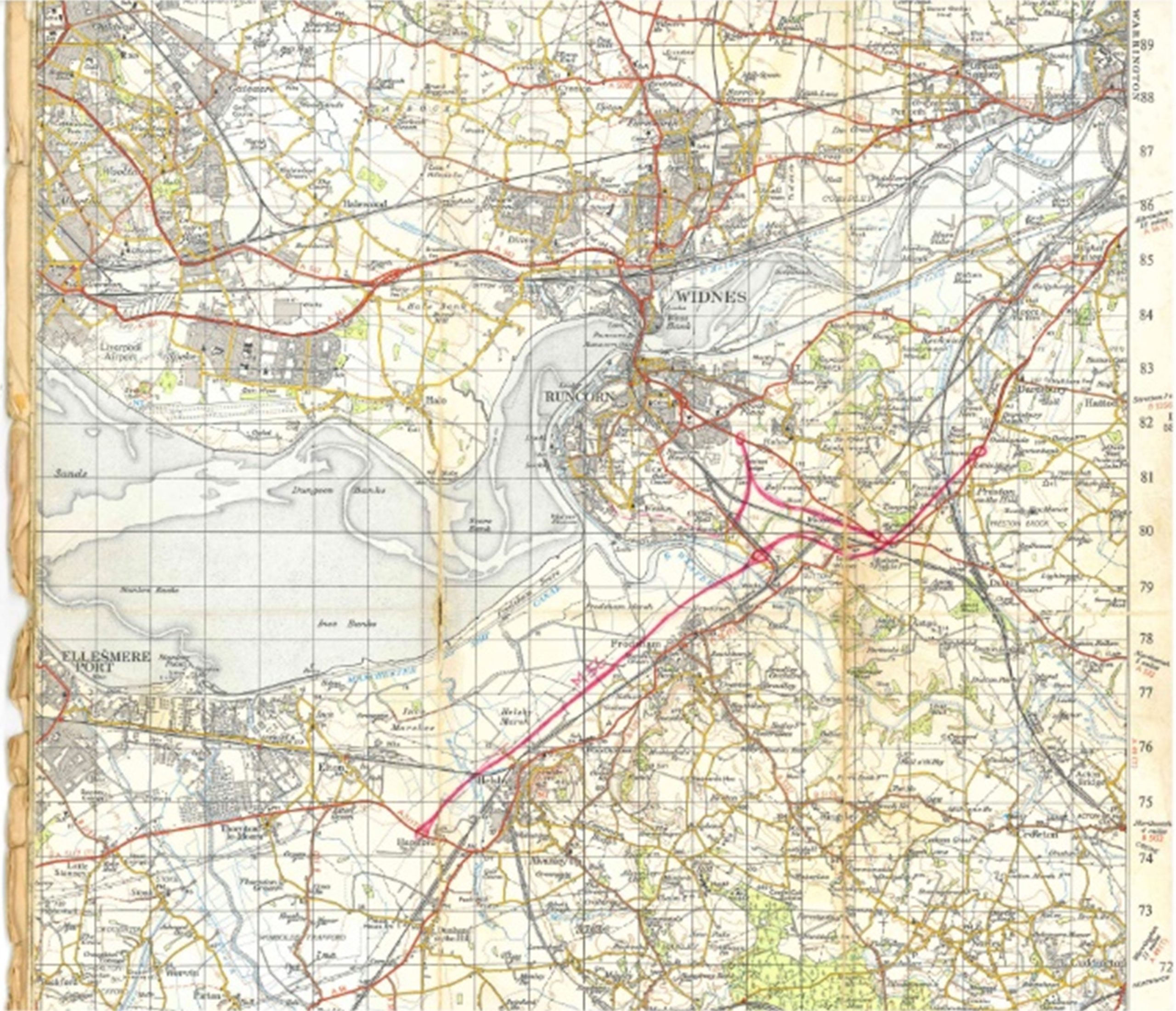
 “The partnership then moved into Highways. It was the early 70s and there was a lot of motorway construction taking place. In fact, it was one of the reasons why we as a family ended up living in Cheshire – the building of the M56. The business secured the contract for the setting out and controls for the motorway. As a reminder of those days, we still have an Ordinance Survey (OS) map with the approximate route of the M56 motorway hand drawn on to it.”
As the road building programme and open cast mining industry slowed EVE Tiltman & Partner started to take on large projects in Nigeria. These contracts lasted for up to about six months. These were generally road and electricity schemes. EVE Tiltman & Partner would run the survey elements of the projects, whilst using and training a local workforce to carry out much of the work.
Laying solid foundations
“In the early 80s housebuilding within the UK took off and this helped grow the business. Eric retired around this time and Mike bought out Eric’s half of the business. He changed the name to be called Powers & Tiltman, keeping Eric’s name as a nod to the business’ founder.
“I joined the business in 1997. I had left school after my GCSEs and joined Cheshire County Council in the civil engineering team, undertaking surveys for other departments within the council. It was a great opportunity to learn and the council also put me through college, I studied at Wrexham University (or Plas Coch Technical College as it was known then). By this time some of the technology had started to be introduced, such as electronic total stations and CAD systems.
“I spent almost eight years with the council, but following some changes within Powers & Tiltman, the time was right to join the family business. And, boy, was it a culture shock! At the council I had learnt a lot about civil engineering and was carrying out topographical surveys using electronic total stations but once I joined Powers & Tiltman I really learned about surveying and hard work. One of my key lessons early on was the importance of a solid and accurate control network which is the bedrock of all surveys! I very quickly also started to get involved in the management side of the business, organising the projects and schedules.”
In 2007 Matt and Lucy Powers bought the business from his parents. By this time, his wife Lucy had also joined the business, and between them, they were running it.
“We put together a package, which we presented to my parents , and after a bit of negotiation we reached a deal. Unfortunately, our timing couldn’t have been worse. We had a great first quarter and then the 2008 crash hit us really hard. During this period, we lost 60% of our turnover over the next four months.
“We had to act fast. We offered some of our team voluntary redundancy and reduced our working week to four days. We also made a strategic decision to keep our senior team, even though the costs would be high, so that when things picked up again, we already had the right people in place to ramp back up quickly. Within 12 months, the outlook was much more positive, and we started rebuilding our team.”
Since then, the business has gone from strength to strength. It rebranded in 2021 as Powers. The company now employees 16 people and has taken on six apprentices over the last four years.
What has made the biggest difference to surveying?
“Looking back over the last 50 years, the biggest difference is the improving technology in survey equipment. It has shortened the length of time it takes to capture data on site which means we can deliver a quicker service to our clients than was possible 10 years ago. While we aren’t inventing it or designing it, we are early adopters of all types of geospatial survey equipment, and this has helped us develop our reputation for solid, well-planned, and executed surveys. There have been some downsides to technology improving the speed of data capture on site, as much of the theory and maths that sits behind the data capture has been lost. People can now call themselves surveyors without necessarily having the background skills and expertise to carry out a professional geospatial survey.
If you look at how theodolites have changed, at one time they would have purely provided vertical and horizontal angles, which would need to be hand booked – the distances calculated using logarithmic tables – and then drawn up by hand. Theodolites are now electronic and can store and process digital data as you work.
“All our survey work is processed using computer aided design (CAD) technology and is another huge and ever-changing development – it is now so fast, and the detail is so much more accurate and comprehensive than back in the 80s and 90s.
“The introduction of global positioning systems (GPS) was another big leap – to be able to lock onto an OS grid and datum within seconds. I recall many hours searching for benchmarks on bridges and old buildings and driving into Chester to Bookland to pick up local OS maps to reference the locations.
“A more recent shift is the introduction of 3D laser scanning, using a 360-degree point cloud. Before we invested in 3D laser scanning equipment, we would have to physically measure each required point on the elevations of buildings. Now the 3D scanner scans and gathers millions of points in minutes. This has proven game-changing with regards to the time it takes to capture data and the amount of data caught. The downside is data management, as the points clouds can be huge and we manage and store huge point cloud files.
“Another technology that has changed the face of surveying is the use of drones. Although still not as accurate as traditional methods , they are brilliant for appraisals of large tracts of land and areas where access is difficult or dangerous.
“As well as keeping up with – and mastering – the ongoing changes with software and technology, we have added new services to our portfolio. Providing underground utility tracing and surveying is a relatively new service to us, which we have been carrying out for the last eight years. It now accounts for about 30% of our work.
“Advances in technology continually improve the data we can provide and the speed of work we can do, but it is also one of our biggest threats. Not every new advance is a worthwhile investment, so we like to trial it first and prove its worth before we make the decision to invest. We generally find that once we have the new equipment, we find more reasons to use it.”
No two days the same
Over the last 50 years Powers has undertaken many projects of different sizes and requirements, including some standout ones such as the internal floor plans and elevations of the Shard in London, through to the survey of the roof on the Port of Liverpool building, which included the top floor, roof and its five domes.

“We did an interesting job on the old Wembley Stadium before they knocked it down. The Rugby League club in Widnes wanted to bring Wembley’s twin towers to the town, so we surveyed the top floor of Wembley Stadium and its towers, providing elevations and floor plans.
Ultimately, the Twin Towers never did make it to Widnes, but it was still an interesting project to work on.
“We have also carried out topographical surveys for the whole of Liverpool’s waterfront from the tobacco warehouse at Stanley Docks, along the Leeds Liverpool canal, and through to Albert Docks.This included using sonar for the dock depths. Surveying top secret, nuclear-proof, Cold War tunnels was interesting too.
Interesting challenges
As with every job, surveying has its challenges and risks. “We mitigate the risks we are faced with in the planning stage of all projects. We can be the first people on a site, sometimes months before any other contractors arrive. There are often derelict buildings or industrial works to deal with. None of this fazes us though, we just carry out the necessary RAMS to ensure everyone is safe – from our surveyors to the client and the general public.
“In truth, dealing with the general public can be our biggest challenge. People want to know what we are doing, and we are not always at liberty to tell them, so we must be able to deflect their questions, while still be professional and polite.
“The security of our kit can also provide challenges. Some of the kit is very expensive and we risk it being stolen from under our noses.”
Addressing the skills gap
The geospatial profession, like much of the construction industry is experiencing a skills shortage, but Powers is doing its best to address this through Lucy Powers’ work as co-chair of the geospatial apprenticeships trailblazer group, which is currently talking to technical colleges across the country to encourage them to adopt the apprenticeship, along with the new, mandated level three Diploma in Geospatial Surveying qualification.
 In addition, Powers has taken on six Geospatial Survey Technician Apprentices over the last four years and is keen to share the advantages and benefits of surveying with the next generation.
“The work is massively varied from city centre projects to power stations or wind farms. The joy is, you don’t need to choose just one area to work in, you can really work in them all. There are so many facets within geospatial surveying, and a surveyor can find themselves working on all types of projects, in all manner of sectors – anywhere within the UK or the world. Even the work itself gives you a variety of on-site work collecting the data and processing it in the office.”
Horizon scanning
The geospatial surveying profession is constantly evolving. As technology advances, so does the scope of the surveyor. Looking ahead, the next thing is likely to be digital environments.
“We are already using digital twins to enable our clients to explore their projects in detail, without having to step foot on a site, which reduces carbon emissions and creates time and cost efficiencies. The digital environments are just the natural progression, enabling clients to interact with their projects using different software. The technology already exists, it is now a case of exploring the art of the possible.
“Using sonar to map underwater is another untapped area and one we have been investigating with partners. And of course, there is also the solar system – and who knows what opportunities are out there, you just need to be open to the possibilities.
Here and now
Powers is in a strong position and is focused on developing the wider team. The team is always looking for new opportunities and is currently excited about the 360-degree photography, which they are providing to their clients. “This will be great for things like work in schools, where the less the project team are on-site, the better. A 360-degree virtual space is where you can really get a grasp of what is happening.
“It is an exciting time for the surveying profession, and we are looking forward to what the next 50 years will bring. However, right here, right now, the last 12 months have been all about meeting new clients and developing stronger relationships, understanding how our clients work and helping them to understand how we work. We have also taken some time to see how we can improve our services and make sure our clients feel supported by us and the work that we do.”
For further information on Powers visit www.powersuk.com. For information on the level three Geospatial Survey Technician Apprenticeship, please contact Lucy on surveyors@powersuk.com.


