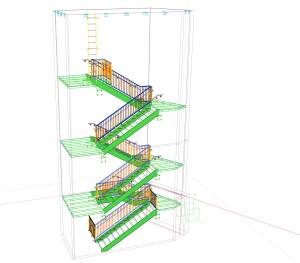
It is a well-known adage that ‘a picture is worth a 1000 words’, meaning that a complex idea can be explained much easier visually. Taking this one step further, a 3D image of a proposed development is much easier to understand than a description or even a flat plan. To this end 3D models are increasingly being used by councils, developers and communities to help them understand the impact of proposed developments in their area.

An accurate and measured view of a building proposal can help both experts, and the general public, understand the impact on space, light, views and the surrounding environment, that a development will have. In particular, they are increasingly being requested by planning authorities as professionals seek to understand the impact of the accurate placing of a building within the current cityscape.
Informing decisions
More and more frequently, 3D models will have an important role in the decision making process and will be used to support Environmental Impact Assessments (EIA), Daylight and Sunlight, Overshadowing, Solar Glare and Light pollution assessments as well as for Right to Light analysis.
Picture the difference
From an architect’s point of view these renderings also provide an initial realisation of the designs that they have developed, enabling their concept to be more easily envisaged.
Increased acceptance
By modelling what a redevelopment or housing project will look like, developers provide themselves with increased chances of public acceptance. Generally, concerns and opposition are raised when there is no clear understanding of how a new building or redevelopment will impact on the local area. By providing 3D model within the context of the existing area during the consultation phase, concerned residents and businesses have the opportunity to visualise, question and accept the proposal.
There are also benefits from a marketing perspective too, as an attractive 3D image can make the difference to marketing collateral when the ‘real thing’ doesn’t already exist.
Accuracy is key
Although at this point, it is ‘only’ a 3D model, carrying out accurate measured topographical surveys at this stage ensures that as the development progresses there is less likelihood of unwanted surprises, and the project is easier to keep to time and budget.
At Powers & Tiltman Land and Measured Buildings Surveyors, we can work with you throughout your development’s journey from providing 3D models at concept, through to final ‘as built’ surveys at your project’s completion. Contact us to find out more.


