This site uses cookies. Find out more.
Close menu icon
  • Our Services
        • Land & Buildings

          • Measured Building Surveys
          • 3D Laser Scanning
          • 3D Models
          • Topographic Survey
          • Boundary Surveys
          • Accurate Measured Viewpoints
          • 3D Revit Model
          • Mobile Mapping
          • UAV (Drone) Surveys
        • Site Engineering

          • Setting Out for Construction
          • Machine Control
          • 3D Ground Modelling and Volumetrics
          • As Built Survey
          • Deformation and Movement Monitoring
        • Underground Services

          • PAS 128 Underground Utility Detection Survey
          • Topographic Survey
  • About Us
    • About Us
    • Responsible Business
    • Project Lifecycle
    • Careers
  • News
  • Projects
  • Contact Us
Skip to content
  • Our Services
        • Land & Buildings

          • Measured Building Surveys
          • 3D Laser Scanning
          • 3D Models
          • Topographic Survey
          • Boundary Surveys
          • Accurate Measured Viewpoints
          • 3D Revit Model
          • Mobile Mapping
          • UAV (Drone) Surveys
        • Site Engineering

          • Setting Out for Construction
          • Machine Control
          • 3D Ground Modelling and Volumetrics
          • As Built Survey
          • Deformation and Movement Monitoring
        • Underground Services

          • PAS 128 Underground Utility Detection Survey
          • Topographic Survey
  • About Us
    • About Us
    • Responsible Business
    • Project Lifecycle
    • Careers
  • News
  • Projects
  • Contact Us
Hamburger menu icon

Month: August 2022

Drone surveying and mapping

Posted on August 15, 2022 (September 13, 2023) by Lucy Powers
Drone being used with an tablet screen facing the screen

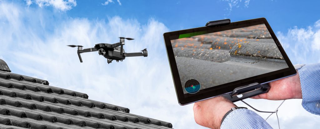
What is a drone survey? Drone surveying is the process of acquiring data from an aerial viewpoint. Combining images or a LiDAR scan produces a high-resolution image. These images each carry a set of 3D coordinates, which enables further processing to assemble them into a sketch with accurate measurements. The practice of autonomous drone mapping …

Read More

Posted in News, Survey ServicesLeave a comment

Recent Posts

  • One version of the truth – Asset Registers
  • A day in the life of… Chris Snow, senior land and underground utilities surveyor at Powers
  • NUAR – what is NUAR and what does it mean for underground utility detection?
  • Helping to build community spirit
  • A day in the life of… Joe Laughton, senior surveyor at Powers

Recent Comments

    Archives

    • March 2025
    • November 2024
    • October 2024
    • September 2024
    • August 2024
    • July 2024
    • June 2024
    • May 2024
    • April 2024
    • March 2024
    • February 2024
    • January 2024
    • December 2023
    • November 2023
    • October 2023
    • September 2023
    • August 2023
    • July 2023
    • June 2023
    • May 2023
    • April 2023
    • March 2023
    • February 2023
    • January 2023
    • December 2022
    • November 2022
    • October 2022
    • September 2022
    • August 2022
    • July 2022
    • June 2022
    • May 2022
    • March 2022
    • February 2022
    • January 2022
    • December 2021
    • November 2021
    • October 2021
    • September 2021
    • August 2021
    • March 2021
    • February 2021
    • January 2021
    • November 2020
    • October 2020
    • June 2017

    Categories

    • Education
    • General Comment
    • News
    • Recruitment
    • Survey Services
    • Thought Leadership
    • Uncategorized

    Meta

    • Log in
    • Entries feed
    • Comments feed
    • WordPress.org
    Integrated
    Survey Partner
    All rights reserved.
    © 2025 PowersUK Ltd
    Celebrating 50 years
    Subscribe to Our Monthly Newsletter Email
    Follow Us
    • Powers on LinkedIn
    • Powers on Twitter
    • Powers on Instagram
    • Powers on Facebook
    Terms & Conditions Privacy Policy & Cookies
    Website by Stride